
Site of mineral railways, Sirhowy Hill Woodlands


![]()
The northern end of Thomas Ellis Way follows the route of a mineral railway. The road is named after an engineer who built early steam locomotives in Tredegar, as you can read on our page about Tredegar ironworks.
The Sirhowy Hill Woodlands area was once crossed by various tramways, where horses hauled coal and iron from pits. One route went to Ebbw Vale through Harford’s Tunnel.
The main routes were upgraded to mineral railways, worked by locomotives. By the end of the 19th century there were mineral railways running north from No.9 Pit and No.4 Pit. If you’ve just scanned the QR code, you’re close to where one railway descended to the Sirhowy ironworks.
 A longer railway diverged and stayed at a higher level, continuing past Sirhowy. It gradually curved through 180 degrees at the head of the valley, passing south of Rassau to reach Ebbw Vale steelworks. Coal trains could reverse above the Sirhowy ironworks site to access the coke ovens to the south (alongside today’s Chartist Way). Coal was turned into coke for steelmaking.
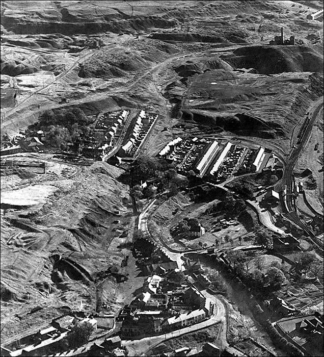
The mineral railways were still in place in the late 1930s but had been lifted by 1948 when the RAF took the aerial photo, shown here courtesy of the Welsh Government. The chimney of No.9 Pit is prominent in the upper right corner. From there you can trace the route of the railway to Ebbw Vale leftwards.
The railway which descended to the Sirhowy ironworks site (at the bottom of the photo) passed between the two groups of terraced houses (Harford Street to the left). Beyond the main group of terraced houses there was a U-shaped connecting railway down to the main Sirhowy Valley railway to Risca, visible on the right. Near the bottom right corner is Sirhowy railway station and its yard for local goods.
Grid reference: SO146095 View Location Map