
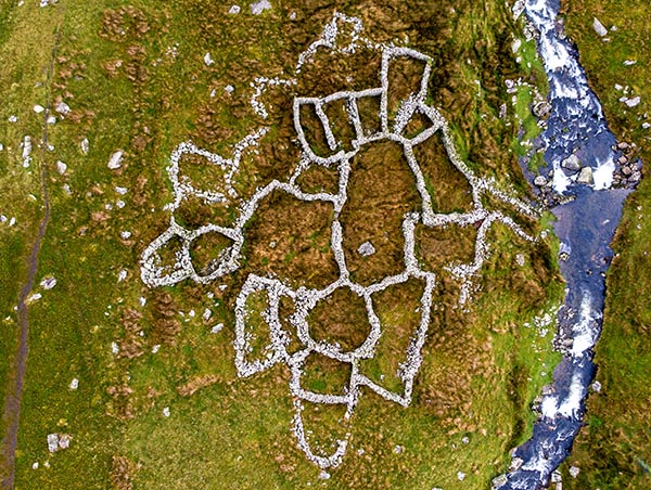
Buarth Mynydd Du sheepfold
![]()
This multi-cellular sheepfold is one of many in the Carneddau in Eryri where the sheep that graze on the mountain slopes are gathered and sorted at specific times of the year.
It sits near the entrance to Cwm Pen Llafar 392 metres above sea level. In Welsh, 'corlan' is the word generally used to refer to an enclosed space for keeping sheep, but, in the Carneddau area, 'buarth' is often used when referring to gathering pens.
 A large proportion of the Carneddau is unenclosed common grazing land, where sheep from different farms mingle during the spring and summer months. Farmers work collectively to gather all the sheep three times a year: in July for shearing; in September for separating the lambs from the ewes; and in October or November when all the sheep are brought down from the mountain to graze on lower ground over winter and to prepare for lambing.
These multi-cellular sheepfolds are communal structures, and like many others, Buarth Mynydd Du is still in use today. It has 21 cells, including a large collection cell near the centre, where the sheep are driven ready to be sorted into the individual cells assigned to each farm. Farmers identify the sheep by the coloured markings on their backs or by their 'clustnodau' (cuts in the ears which are unique to each farm) and drive them through creeps - holes in the internal walls - into the smaller cells around the middle.
Sheep that do not belong to any of the farms that use the sheepfolds are returned to their owners by the chief shepherd, or 'setiwr'. This name is derived from the English word 'escheater', a royal official in mediaeval times whose job was to claim assets for the Crown when a person died without any heirs.
The oldest sheepfolds of the Carneddau date from around the 18th century, when large estates and wealthy individuals began to enclose the common land on the mountains. Sheep replaced cattle as the main grazing animals on the Carneddau as they were more profitable, especially when the demand for sheep’s wool and meat increased during the Napoleonic wars 1800-1815.
Buarth Mynydd Du appears on a map dated 1786 and it was probably built sometime in the 100 years before this.
With thanks to Nigel Beidas of Cofnodi Corlannau
Grid reference: SH 64991 65354 View Location Map
Website of Cofnodi Corlannau – details and photos of the Carneddau sheepfolds